Dissapearance
The flight departed from Kuala Lumpur International Airport on 8 March at 00:41 local time and was scheduled to land at Beijing Capital International Airport at 06:30 local time. It climbed to its assigned cruise altitude of 11,000 m and was travailing at airspeed 872 km/h when it discontinued all communications and the transponder signal was lost. The aircraft's last known position on 8 March at 01:21 local time was 6°55′15″N 103°34′43″E, according to the navigational waypoint IGARI in the Gulf of Thailand, at which the aircraft was due to alter its course slightly eastward. Military radar tracking shows that the aircraft decreased its altitude to 3,700 m after taking a sharp turn toward the Strait of Malacca. The sharp turn seemed to be intentional seeing that the plane would have taken 2 minutes to make such a turn, and during that time there was no emergency call.
Timeline of disappearance
Malaysian airlines route before disappearance and possible route after disappearance

This is map demonstrates the route of Malaysian Airplane before and possible route after its disappearance.
Search operation. Estimated routes
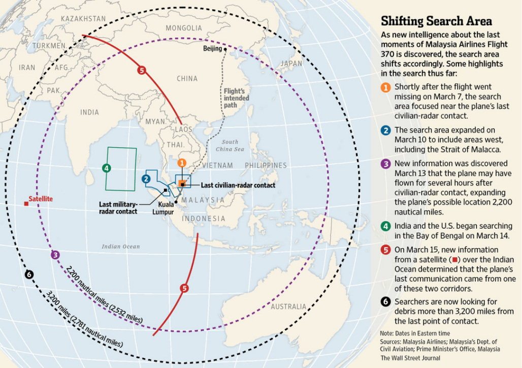
Estimated routes
Possible last known locations of MH370 in red, based on final satellite ping at 08:11 Malaysia time
On 11 March, it was reported that military radar pointed the aircraft had turned west and continued flying for 70 minutes before disappearing off the Malaysian radar near Pulau Perak, and that it was tracked flying at a lower altitude across Malaysia to the Malacca Strait. This location was approximately 500 kilometers from its last contact with civilian radar. The next day, the Royal Malaysian Air Force chief distanced himself from the report saying it should not be misinterpreted. Reported by the Vietnamese Deputy Minister of Transport, Pham Quy Tieu, "We informed Malaysia on the day we lost contact with the flight that we noticed the flight turned back west but Malaysia did not respond."
US experts, assigned to assist with the investigation in a low-key manner consistent with conventions of responsibilities, analyzed the radar data and subsequently reported that the radar data did indeed indicate that the aircraft had headed west back across the Malay Peninsula.
Although Bloomberg News reported that analysis of the last satellite "ping" received suggested a last known location approximately 1,600 km west of Perth, Australia, the Malaysian Prime Minister Najib Razak on 15 March said that the last signal, received at 08:11 Malaysian time, might have originated from as far north as Kazakhstan. Najib explained that the signals could not be more precisely located than to one of two possible location, a northern locus stretching approximately from the border of Kazakhstan and Turkmenistan to northern Thailand, or a southern locus stretching from Indonesia to the southern Indian Ocean. None of the countries on a possible northerly flight route – China, Thailand, Kazakhstan, Pakistan, and India – stated that there was any evidence that the aircraft ever entered their airspace.
Search operations in Southern region near Australia

Acting Malaysian Transport Minister Hishammuddin Hussein has revealed that the latest analysis of satellite included a final electronic signal that was still being investigated.
"There is evidence of a partial handshake between the aircraft and ground station at 0019 UTC (GMT)," he told a news conference on Tuesday. "At this time, this transmission is not understood and is subject to further ongoing work."
He said that as a result of the latest analysis, the area of search operations had been narrowed from 2.24m sq nautical miles to 469,407 sq nautical miles, and an international working group had now been convened to try to further narrow the search area.
Operations in the "northern corridor" - one of two large areas where the plane might have ended its journey - had been completely called off to concentrate on the southern part of the "southern corridor" in the Indian Ocean west of Perth, he added.
